What is land surveying?
Land surveying is the practice of measuring up existing land parcels, buildings or historic reference marks to accurately determine existing site conditions and subsequent construction or development advice. It is an essential part of every land development from entire precinct estates through to new single dwelling builds. Land surveyors are adept at thinking, working in 3D, and using mathematical methods and specialised equipment to produce initial site data for pre-construction work and physical marks on the ground to direct construction on the ground.
What is it used for and why is this information important?
Land surveying for new builds is a crucial step that most developments require in the beginning stages of construction – Particularly when executing land development, planning and design, or before purchasing a piece of property. The information that is gathered from land surveying is important for:
Determining legal boundaries
A surveyor will investigate your legal description in the form of a land parcel defined by a Certificate of Title. This certificate defines exactly where your land is in relation to adjoining land parcels, which is then utilised to clearly measure and locate the land’s property boundaries. Establishing your property boundaries allows you to understand the limit of land owned and can be used to determine the final location of fences and buildings lines to avoid disputes with neighbours due to illegally building over a title boundary. Our qualified surveyors initially measure up the subject land and provide a plan that clearly indicates exact title boundaries as well as pegs or other physical marks to identify boundaries on the ground. These marks are then used, particularly in situations where old fences have been removed or placed incorrectly.
Determining land levels and features
A surveyor can measure the entire site including, levels, existing structures, trees, services, and any other pertinent elements to development or building. The information is generally placed on a plan which is then used for siting or planning of new developments such as re-subdivisions, roads, and single dwellings. The plan gives designers an accurate scale representation of what exists at a certain point in time allowing new work to be accurately planned out. The site levels are one of the most critical parts of this process as water drainage issues are the most common cause of building problems. The level and feature information are often combined with the legal boundaries to ensure that the design not only works in the physical space but will also not create any boundary encroachments which could lead to expensive rectification works.
Before purchasing a piece of property
Conducting a land survey prior to purchasing a piece of property ensures that you are completely aware of what you are buying so that you are not faced with any unpleasant surprises in the future. A land survey will help you clarify your property rights, restrictions, and any undiscovered encroachments from your neighbours that are on your land, or where you may have an illegal encroachment into your neighbour’s land. This can also confirm the land size, slope of the land or tree or service location, which may be critical for design purposes and determine whether a project is viable or not.
How is it conducted?
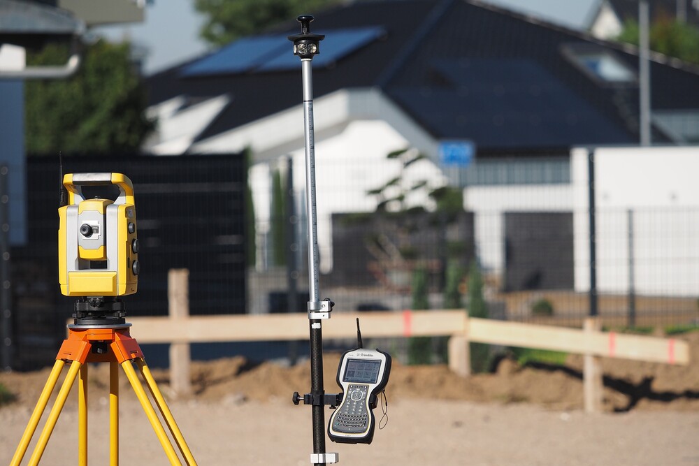
When supplied with a site address and copy of any title documentation, our surveyors can carry out a basic desktop study to determine what survey would need to be conducted to suit the purpose, i.e. New dwelling build, drainage design, fencing works. Following this, a site visit is organised to carry out all measurement work using Robotic total stations, GPS and survey drones. The data gathered on-site is then reduced on-site or in the office using specialised surveying software to give basic on-site information or a final plan with all elements clearly laid out for use during the life of the project. Once construction has commenced, our surveyors will return to the site to place pegs and other marks to guide the construction or provide an as-constructed verification of built forms.
It is crucial for all of the above work to be accurately performed by experienced surveyors, as imprecise data used throughout the project could cause major discrepancies in the finished product, and may lead to legal issues. With our licensed and experienced Land Surveyors plus all the right tools, we can help you to execute an accurate assessment of your site to avoid these costly errors and proceed with your project in confidence.
Contact us today if you’re looking for Land Surveying on your new build.
*Please note – this service is not available in WA.
Back to News